Embracing PODs
Advancing wildfire response planning
BY ALEXIS NEUKIRCH, DAVID CALKIN, CHRISTOPHER O’CONNOR, MATTHEW THOMPSON, CHRISTOPHER DUNN AND MICHAEL CAGGIANO
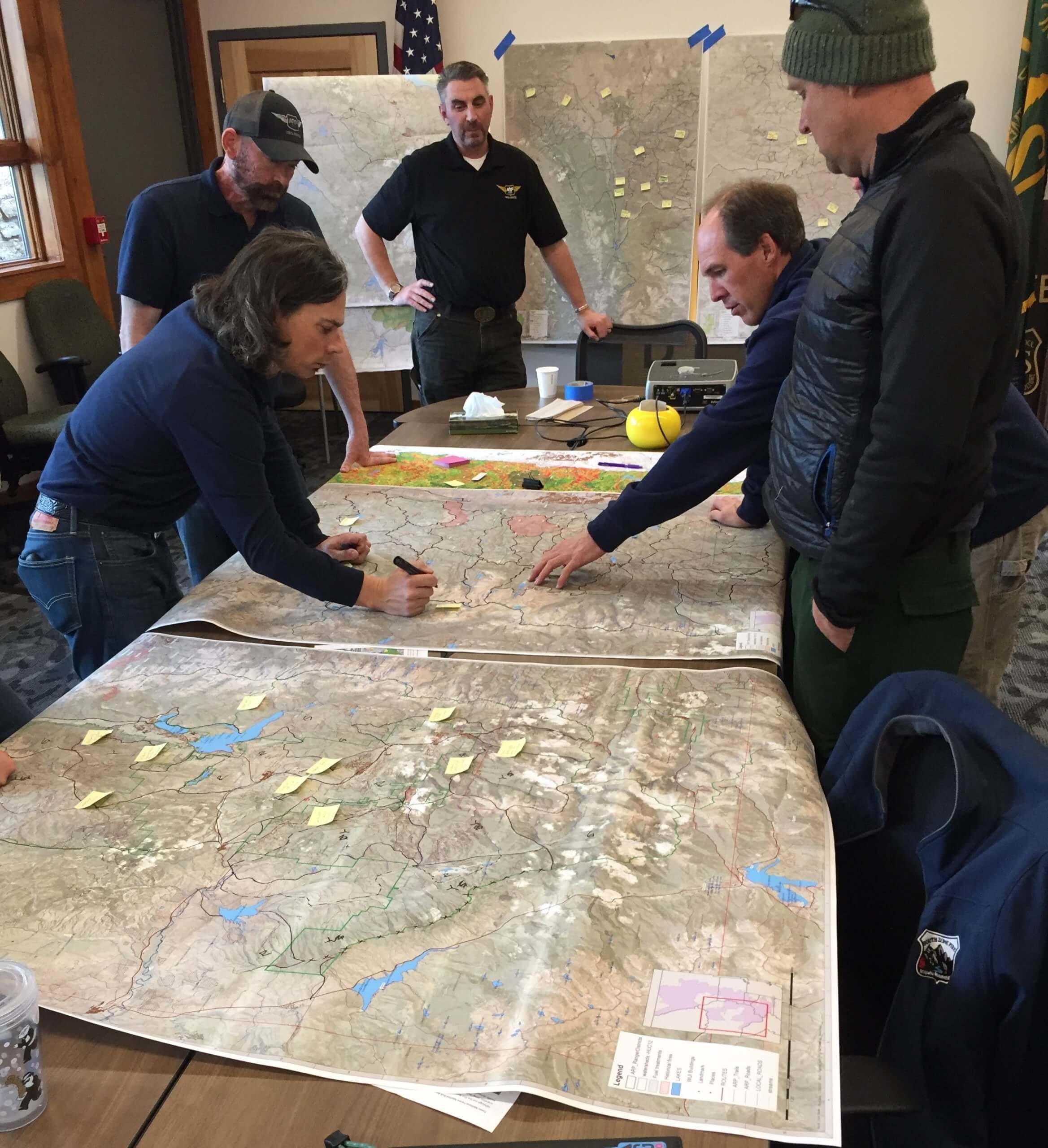
A team of fire managers developing PODs, potential wildfire operational delineations, on the Arapaho Roosevelt National Forest in February 2018.
Photo by Matt Thompson
PODs, potential wildfire operational delineations, give land managers, fire managers, partnering agencies, and at-risk communities a structured framework for developing landscape-scale wildfire response options before wildfires ignite.
“PODs are a great example of Forest Service research meeting the on-the-ground needs of the agency and the nation,” said Vicki Christiansen, USDA Forest Service chief, as she kicked off the virtual PODs Collaborative Fire Planning Workshop on Feb. 24.
“As a science-based agency and a learning organization, we are using PODs to integrate our best knowledge about fire management and the ability to collaboratively plan,” Christiansen said.
More than 450 land managers, planners, fire responders, scientists, and consultants participated in the two-day workshop hosted by the USDA Forest Service Rocky Mountain Research Station’s Wildfire Risk Management Science team and its partners at Oregon State University and Colorado Forest Restoration Institute. The workshop featured case studies presented by a diverse panel of speakers, presentations of challenges facing PODs implementation and use, and five breakout sessions for closer engagement.
Responding to wildland fire requires partnerships. As of the spring of 2021, 43 national forests across the United States have used the PODs framework together with their fire manager counterparts at other federal, state, county, and local agencies.
PODs are “containers” drawn on a map that are defined by potential fire-control features, such as roads and ridge tops, and can be used to summarize risk to landscape values in a way that is useful for communicating and coordinating response to wildfires before they occur. PODs also provide a strategic framework for restoration and fuel-reduction activities that can improve suppression effectiveness when needed and help get more of the right kind of fire in the right place where appropriate.
A brief history of PODs
PODs is one of the new goal-oriented and forward-looking approaches that deemphasize fire exclusion, expand application of prescribed and managed natural fire, and foster resilience of ecosystems and communities and adaptation to fire. The National Cohesive Wildland Fire Management Strategy in the United States focuses on making meaningful progress towards attainment of resilient landscapes, fire adapted communities, and safe and effective response to fire. How fires are managed – not just how landscapes are managed or how communities respond before and after fires occur – is a key determinant of long-term socioecological resiliency and the ability to “live with fire.”
The PODs framework is the product of researchers collaborating with local land managers to put robust data behind a good idea. The framework blends local expertise with advanced analytical tools to quantify and visualize wildfire risk to highly valued resources and assets, potential control locations (PCL), and the level of effort required to engage a fire at any point on a landscape, or the Suppression Difficulty Index (SDI).
Leading with the assessment of wildfire risk allows managers to map out the most likely positive and negative outcomes from wildfire and then leverage the PCL and SDI tools, with local knowledge, to break up landscape-level risk into operational containers that can be classified by their primary risk profile. Taking this one step further, the risk summary can be used to define risk-informed wildfire response objectives at the POD-level and to further map out defensible strategic response zones across a landscape. Grounding fire planning in spatial risk assessment methods directly links risk management principles to fire management decision making and increases the likelihood of attaining the goals outlined in the cohesive strategy.
The initial application of this work was led by the efforts of Phil Bowden, retired regional fuels planner in the Pacific Southwest Regional Office, and his team on several national forests in the Southern Sierra Nevada area of California. This pilot application served as the springboard for POD-based strategic fire planning throughout the western United States.
Further cementing the connection between data analytics and on-the-ground decision making, the PCL atlas and SDI were introduced to the PODs framework in 2016 and wildfire response decision shortly thereafter. These tools provide a common operating picture for fire management opportunities and challenges that can be used to rapidly assess planning and response options (see The Path to Strategic Wildland Fire Management Planning). PCL and SDI have also gained popularity as tactical decision support tools on more than 140 large wildfire incidents from 2017 to 2020. Through feedback from land managers and incident management teams, these products have undergone a series of improvements and updates and are now available annually at west-wide (PCL) or national (SDI) scales.
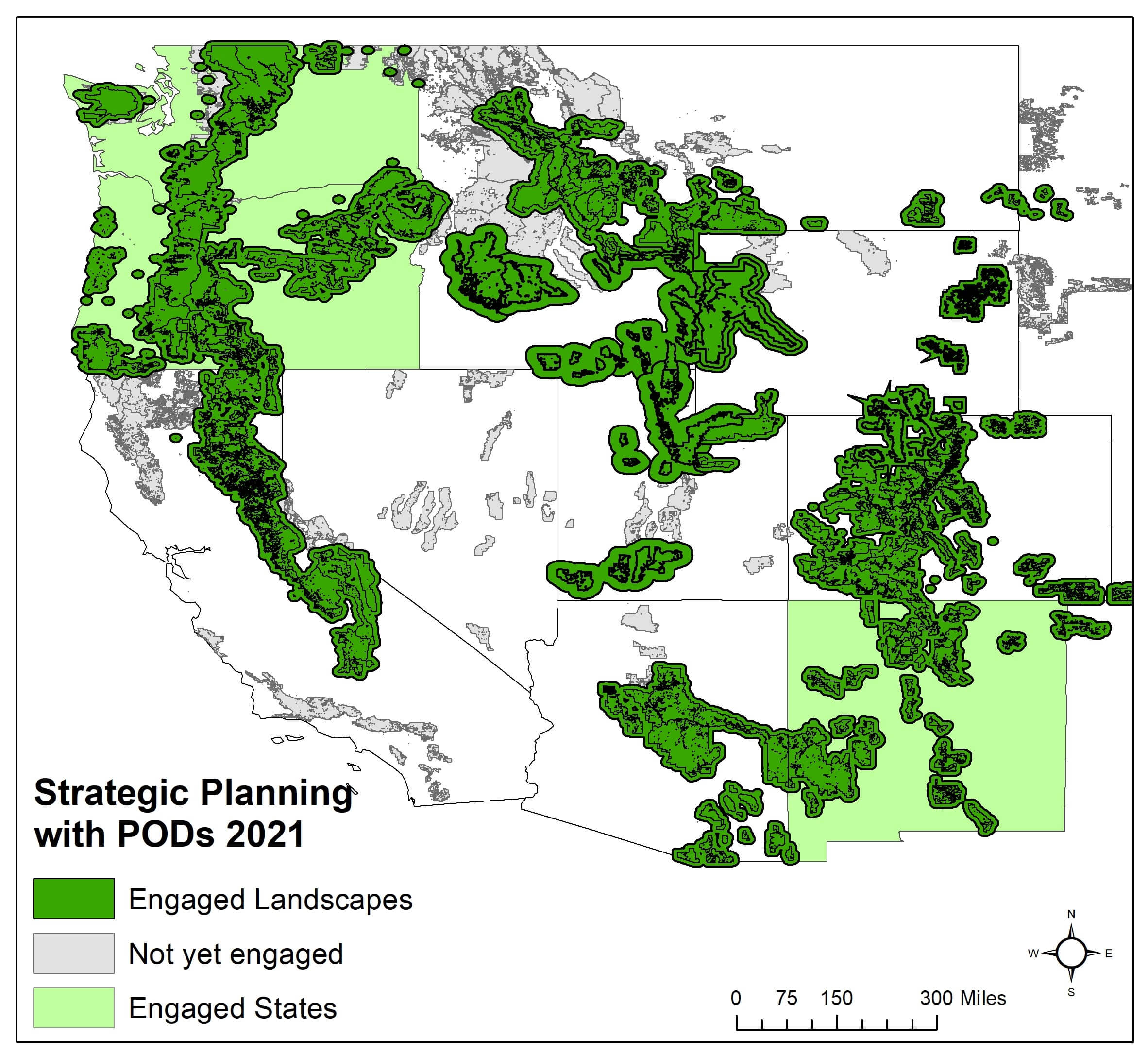
This risk-based spatial fire planning framework was first applied to a wildfire incident during the summer of 2017 on the Pinal Fire, located on the Globe Ranger District of the Tonto National Forest (see: Engaging the Fire Before it Starts: A Case Study from the 2017 Pinal Fire (Arizona)). Since this experience, numerous Forests, partnerships, NGOs and state agencies have engaged the POD framework to structure their shared risk around wildfire management (Figure 1). PODs supports the full range of wildfire responses from aggressive suppression in high risk areas, and conditional based response in areas where the balance between beneficial and negative consequences is largely determined by current and forecasted fire weather, to maintenance or reintroduction of fire to low risk areas were fire can assume its natural role in ecosystem processes reducing future risk potential.
Themes
The PODs framework is illustrative of how shared stewardship is playing out on the ground – it is proactive, fosters co-management of risk, and creates the opportunity for cross-boundary planning implementation and fire response before the smoke is in the air. PODs facilitate risk informed response and strategic management of wildland fire, aligning activities to address the most current threat to ecosystems and communities alike. High octane, sophisticated science paired with land and fire managers’ on-the-ground-knowledge is working in partnership to improve the safety and effectiveness of fire management. Communication during the PODs framework is structured around fire objectives and opportunities, and managers have successfully used PODs to respond to high complexity full suppression events, manage natural ignitions in remote areas with low risk strategies, and plan prescribed fire strategies to reduce an area’s current wildfire risk. This type of community pre-fire planning expands implementation of the National Cohesive Wildland Fire Management Strategy, integrates fire into landscapes in a way that minimizes risks to lives and property, and builds long-term forest and grassland resilience.
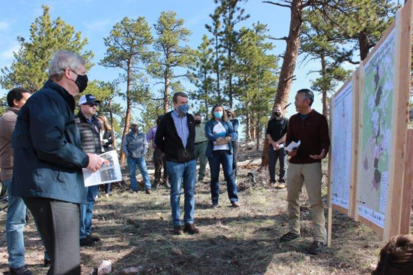
Photo courtesy Petra Popiel, USDA Natural Resource Conservation Service
Fuels management and active fire incidents
In northern California, Jason Kuiken, forest supervisor, USDA Forest Service, Stanislaus National Forest, is using PODs for strategic fuels management on the Stanislaus landscape. By using PODs in combination with the Social and Ecological Resilience Across the Landscape (SERAL project), Kuiken is creating strategic fire management features where unplanned fire can be successfully halted before reaching the many communities near the forest. In northern Colorado, fire and land managers are using PODs to strategically manage fuels before fires start. Managers selected a north to south continuous line of PODs to undergo fuels management projects to stop future fires as they move from west to east.
“To plan for fire on large landscapes, you have to think about your fireshed, build a strategic plan for that landscape and complete specific, local treatments to support that plan,” aid Monte Williams, Forest supervisor on the Arapaho and Roosevelt National Forests and Pawnee National Grassland, during the PODs workshop. “Using the PODs approach helps you carve the landscape into smaller pieces.
“The old adage is ‘How do you eat an elephant? One bite at a time.’ In our case, maybe one PODs at a time. The PODs framework also gives you the ability to communicate easily with your partners and the public about what you are doing to manage future fires and why you are doing it.”
Washington State Department of Natural Resources (DNR) is integrating PODs into its 20-year forest health strategic plan for eastern Washington, which includes the evaluation of 39 high priority, multi-ownership watersheds. Land managers and owners will be able to use the information from the evaluation in future decision making.
At the 2021 PODs workshop, Ana Barros, Washington DNR fire scientist, described how during the evaluation, the DNR is analyzing the landscape with the goal of both improving forest health and benefiting fire operations. The DNR integrated PODs into the assessment to evaluate both of these factors, generate buy-in from the community, and create a map that can be used in future decision making for forest health and fire operations. By combing PODs with a wildfire response benefit assessments and landscape treatment prioritization, the team created a cohesive map with three classes of ranked PODs based on landscape treatment prioritization and forest health needs that can inform decision makers on each landscape.
Brad Pietruska, fuels program manager on the San Juan National Forest, demonstrated how PODs can be used to quantify potential suppression opportunities during active high complexity incident management. During the 2020 Pine Gulch Fire on the San Juan National Forest and Mullen Fire on the Medicine Bow-Routt National Forest, Pietruska used the PODs framework to generate data about the potential for controlling fire at different locations. He combined the likelihood of fire holding at different locations using PCL, amount of suppression work needed to prepare containment lines, and estimated fire arrival time at these locations. This process helped the incident management team recognize that a larger, more comprehensive strategy was necessary. In fire lingo, the team was able to identify that the next ridge was not the best ridge (however in this example it was roads instead of ridges).
Challenges
Although PODs have been developed on 43 USDA forests and used in many active fire incidents, fire managers still face challenges developing and utilizing PODs. The PODs framework simultaneously depends on and facilitates cross-boundary communication and co-production of knowledge. Both the PODs framework and working together on land and fire management problems requires communities to break down silos among organizations and disciplines. PODs can help address these existing sociopolitical tensions and challenges to collaborative landscape management, but its successful adoption still hinges on these same factors. Following successful collaboration and development of PODs, the information needs to be effectively conveyed to and used by incident management teams, which can present additional challenges. Finally, PODs require maintenance, reassessment, and continued collaboration over time, which can be impeded by low staff capacity and capability. Addressing these challenges will require continued and additional effort to support working across boundaries and dedicating time and capacity to pre-fire planning.
What’s next?
The PODs approach is still growing and evolving as managers and scientists develop new applications. For example, PODs practitioners are beginning to extend PODs beyond forests to address fire in the wildland urban interface such as in Ashland, Oregon. PODs are designed to be adaptable, and the scientists developing PODs support on-the-ground innovation that land and fire managers bring to the process. Through continued conversation across physical and jurisdictional boundaries, the PODs framework has the potential to continue to facilitate co-production of knowledge. PODs connect scientists and managers and will continue to serve as a platform for two-way knowledge exchange and the development of actionable science.
Following the 2021 workshop, efforts were begun to establish a PODs community of practice, a group of federal and non-federal managers, consultants, and scientists interested in expanding the application of PODs in wildfire response planning consistent with the goals of cohesive strategy and shared stewardship. The CoP will provide a platform for connections among PODs users across organizations, geographies, and disciplines, providing new opportunities for the growth of PODs and the evolution of improved strategic wildfire response planning. The Rocky Mountain Research Station WRMS scientists will continue to advance PODs science while PODs users across agencies and communities prepare for each upcoming fire season – one POD at a time.
Learn more about PODs at https://www.fs.usda.gov/rmrs/groups/wildfire-risk-management-science-team/potential-operational-delineations-pods
About the authors
 Alexis Neukirch is an ORISE Fellow with the Rocky Mountain Research Station Science Application and Communication team. Neukirch assists the team with a variety of science delivery projects. Connect with Lexi at [email protected].
 Dave Calkin is a supervisory research forester with the Rocky Mountain Research Station in Missoula, Montana. He leads the wildfire risk management science team working to improve risk-based fire management decision making through improved science development, application, and delivery. His research incorporates economics with risk and decision sciences to explore ways to evaluate and improve the efficiency and effectiveness of wildfire management programs. Contact Dave at [email protected].
Christopher ‘Kit’ O’Connor is a research ecologist with the Human Dimensions Program at the Rocky Mountain Research Station. Kit’s primary research interest is in bridging the human and ecological dimensions of fire management with a focus on ecosystem restoration and resilience, safe and effective suppression response, and sustainable forest and fire management systems. Contact Kit at [email protected].
Matthew Thompson is a research forester in the Human Dimensions Program at the Rocky Mountain Research Station, in Fort Collins, Colorado. His research interests include risk, systems, and decision analysis, applied to questions of forest and wildland fire management. Contact Matt at [email protected]
Christopher Dunn is a research associate in the College of Forestry at Oregon State University. He spent eight years in fire suppression and fuels management prior to pursuing research on fire effects and ecosystem response to mixed severity fires. Today he leverages his operational experience and research training to bridge the gap between science and management to better prepare land and fire managers for the changing fire environment. Contact Chris at [email protected].
Michael Caggiano is a research scientist with the Colorado Forest Restoration Institute at Colorado State University in Fort Collins, Colorado. His most recent work focuses on cross boundary spatial fire planning, prescribed fire capacity building, mapping the wildland urban interface, and evaluating pattens of home loss in WUI disasters. Contact Mike at [email protected].
