Fire-generated storms
Technology improves warning systems
BY BETHANY PATCH
The Pyrocumulonimbus Firepower Threshold (PFT) is new technology that measures the threshold or minimum firepower required for fire-generated thunderstorms to form . . .
Fire-generated thunderstorms have much in common with conventional thunderstorms. Both require warm humid air to be lifted into an unstable layer above. Photo courtesy NSW Rural Fire Service
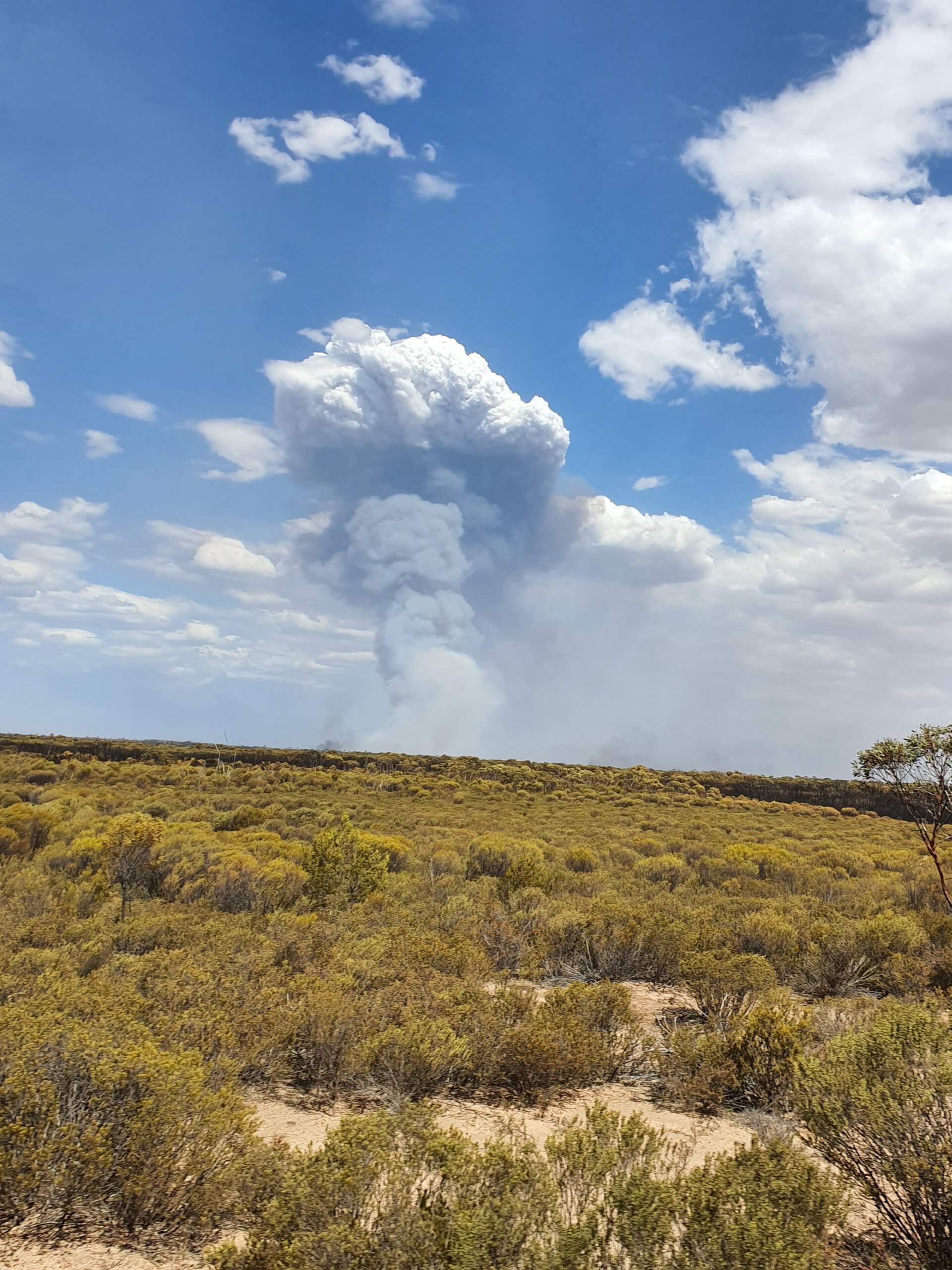
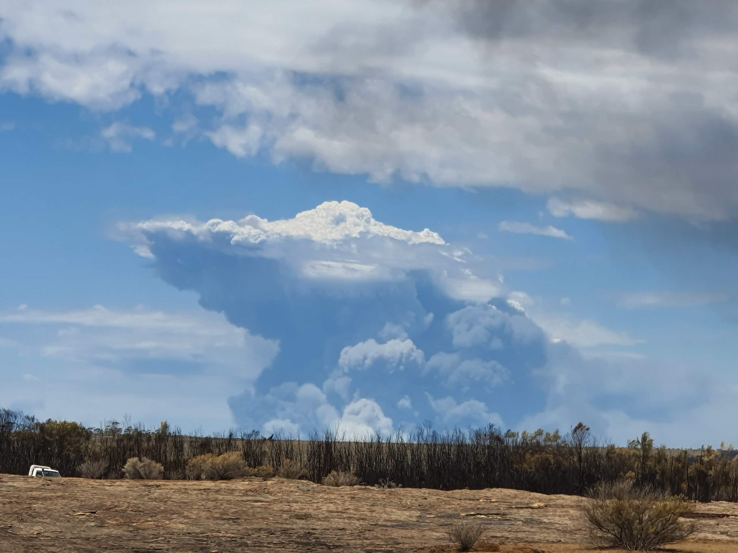
Fire-generated thunderstorms, sometimes called pyrocumulonimbus clouds or pyroCbs, are ferocious weather systems that can exacerbate the damage already caused by the bushfires that create them. While pyroCbs are only just beginning to be understood, research by Australia’s Bushfire and Natural Hazards Cooperative Research Centre is helping measure and predict fire-generated thunderstorms more effectively. This research aims to improve warning systems and assist agencies with analysis and forecasting.
Kevin Tory, senior research scientist at Australia’s Bureau of Meteorology, is part of a team exploring fire-generated thunderstorm prediction. The team’s research has developed a tool that is helping fire agencies and weather forecasters predict when these dangerous storms might occur, so that fire agencies can warn communities and firefighters.
Tory explains that fire-generated thunderstorms have much in common with conventional thunderstorms – both require warm, humid air to be lifted into an unstable layer above. However, far less is known about fire-generated thunderstorms, including why they have become so much more common recently.
“We are getting better at identifying these storms with improved satellite coverage, but this can’t explain the dramatic increase in numbers of events we’ve seen globally in the last few years,” Tory said.
According to Rick McRae, who has been studying fire-generated thunderstorms for almost 40 years, Australia has entered an era of violent pyro-convection since the first closely studied storm in Berringa, Victoria, in 1995.
“PyroCbs are a very strong signal of how badly climate change is impacting the globe,” McRae said. “With normal fires, if you know the fuel, the weather and the terrain, then you know what the fire will be doing, with a few exceptions. A blow-up fire event displays dynamic fire behaviour –they are basically a different species of fire. They develop feedback processes.”
McRae began searching for previous instances of fire-generated thunderstorms in 2003. Prior to 2001, there were two known and two suspected events in Australia. There are now 118 on the list, including 37 during last season’s Black Summer bushfires, which raged through south-eastern New South Wales and eastern Victoria; this made the Black Summer bushfires the most intense series of pyro-convective events ever recorded.
The smoke from fires near Mallacoota, Victoria, eventually reached a height of 35 kilometres, and is now being studied worldwide. Sergey Khaykin at the Laboratory of Atmospheric Research and Satellite Observations at Sorbonne University in France recently reported that the smoke was so thick that it acted like a planetary shade, blocking the sun and briefly creating a cooling effect similar to a moderate volcanic eruption. Of course, not all extreme fires go on to produce intense new weather events, but conditions can become ferocious and significantly destructive when they do, often resulting in far-carried embers or the creation of entirely new fires from lightning strikes.
This kind of firestorm occurs when the hot gases in the smoke plume rise high enough to begin interacting with the atmosphere, causing clouds to form and inducing a powerful local thunderstorm. With the increase in these firestorms, it is becoming easier to identify and predict them with the help of new technologies.
Tory explains that, in some ways, the formation of these storms is very simple to understand. The analysis of fire and plumes is more complicated.
“All you need is an enormously hot fire in an unstable atmosphere and a fire-generated thunderstorm will develop,” Tory said. “The real complexity is in understanding how large and intense a fire would need to become for a specific atmospheric environment, and whether or not you have the right mix of fuels, terrain, local winds and complex fire behaviours that would allow the fire to become large and intense enough.”
According to Tory, a basic understanding of three things is needed in order to grasp how large and intense a fire needs to be to create a fire-generated thunderstorm:
- The height to which smoke plumes rise for any given fire intensity and wind speed. The greater the fire intensity, the taller and more vigorous the smoke plume, whereas the stronger the wind, the more the plume is blown over and spreads out downwind.
- The height to which the smoke plume must rise before it cools enough for cloud to start forming. This requires an understanding of how the temperature and humidity changes with height in the smoke plume.
- The instability of the atmosphere. This determines how buoyant and strong the updrafts in the cloudy plume need to be for a thunderstorm to develop.
A series of Cooperative Research Centre studies has helped analyse plume behaviour more accurately. Building on this research, Tory’s team has focused specifically on the first point, in order to understand how large and intense a fire would need to be to produce one of these fierce storms.
“We focus on the atmosphere, which is much more predictable than fire,” Tory said. “If we know how large and intense a fire will become, and how large and intense a fire needs to be for a fire-generated thunderstorm to form, we can, in theory, predict them. However, predicting the future fire size and intensity remains an enormous challenge.”
Tory’s work has culminated in the development of a diagnostic tool that can determine when the atmosphere is conducive to both deep plume development and large, hot fires. This research is assisting fire agencies and the Bureau of Meteorology with accurate and quick predictions that inform subsequent warnings.
The Pyrocumulonimbus Firepower Threshold (PFT) is new technology that measures the threshold or minimum firepower required for fire-generated thunderstorms to form, essentially assessing the atmospheric potential to support the development of a fire sufficiently large and intense for one of these storms to develop. The technology is proving to be highly predictive.

Photo by Christine Harper, Department of Biodiversity, Conservations and Attractions, Western Australia
“We were surprised how well the tool seems to work,” Tory said. “We seem to have identified a handful of key ingredients, and the way they fit together largely determines how favourable the atmosphere is for fire-generated thunderstorm formation.”
The research team began by using a computer-generated weather forecast to create contour maps of the PFT, then handed them out to a selection of fire weather forecasters and fire behaviour analysts.
“We know that a fire-generated thunderstorm can be very hazardous, but we also know that many are quite benign,” said Tory. “The PFT is great because it helps to pinpoint the threat timing and location.”
Within weeks, these maps were being used to predict the Black Summer firestorms. This allowed the researchers to practise using and refining the tool, identifying its strengths and weaknesses and making improvements. Partnerships with fire and emergency services and other government partners, co-ordinated through the Cooperative Research Centre, have been essential in building and developing the tool. The tool is now used by fire behaviour analysts within fire agencies and land management departments, as well as by Bureau of Meteorology forecasters, who work closely with fire agencies advising on severe weather.
Jamie Molloy, a fire behaviour analyst and program manager of the Forest Protection Survey Program at the Victorian Department of Environment, Land, Water and Planning, explains just how helpful the PFT has been for his team when analysing fires.
“The Pyrocumulonimbus Firepower Threshold is a significant improvement in identifying fire-generated thunderstorm risk, including helping to flag other factors that should be looked at, such as mixed-layer windspeed,” Molloy said.
“I review it every day that I am deployed as a fire behaviour analyst. It gives me a very quick heads-up on the potential, broad timing and location of fire-generated thunderstorms – if the chance of a storm is identified, it prompts further investigation of ignition potential, atmospheric instability and thus the likelihood of firestorms and community risk in those areas.”
In Western Australia, the tool has been used by the Department of Biodiversity, Conservation and Attractions during the past two southern fire seasons. Brett Beecham, having worked in intelligence and predictions for the department for the past 10 years, reiterated how helpful the PFT was when assessing pyro-convection and the risk of extreme fires.
“The Pyrocumulonimbus Firepower Threshold provides one more piece of information about the potential for a fire to interact with the atmosphere around it, and I now use it in conjunction with other tools to gain a better insight into the risks of extreme fire behaviour,” Beecham said.

Photo by Christine Harper, DBCA, Western Australia
“It provides vital information about the likelihood of extreme fire behaviour due to strong pyro-convection, and this ultimately leads to improved firefighter and community safety during a bushfire.”
The PFT is also being regularly used by New South Wales Rural Fire Service fire analysts such as David Philp.
“From the perspective of a fire behaviour analyst for an incident management team, knowing the possible potential storm risk triggers the need for closer monitoring of the broader weather conditions to ensure appropriate storm warnings are issued, rather than waiting for specific warnings being issued through the Rural Fire Service State Operations Centre,” Philp said.
The tool will continue to be improved and expanded as more evidence comes to hand. Tory and other scientists are racing to learn as much about fire-generated thunderstorms and other extreme weather systems as possible, knowing that a better understanding is essential to reducing preventable fire-related deaths.
“If we knew more about what makes fire-generated thunderstorms dangerous, we should be able to tailor some of the ingredients or adjust thresholds to better highlight dangerous events,” Tory said. “More field studies, with every type of monitoring equipment we can think of, will help us better understand these events.”
To learn more about this research, visit the Improved predictions of severe weather to reduce community impact project page.
 About the author: Bethany Patch is a writer in Melbourne, Australia, for the Bushfire and Natural Hazards CRC.

